Description
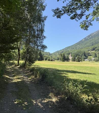
Family trail on ancestral paths, to discover the particularities and riches of our hamlets. Depending on the borrowed diversions, the duration is from 1 to 3.5 hours.
Learn moreMark 1
Departure from the parking lot along the Route de l'Eglise D114c, 30m downstream of the Church, then follow the pictograms.
The church, completed in 1900, is dedicated to St. Anthony the Great, patron saint of farmers and was formerly celebrated on 17 January.
This date was the occasion of beautiful celebrations that spread over several days. Everyone participated in this event and came to share a good time around a coffee, a dish, a dance started by the fiddler.
The parish priest’s ministry is exercised in the hamlets of Moulin-Vieux, Villard sur Lavaldens and the commune of La Morte.
Near the Church, the old parish is today converted into communal housing.
The coating on the walls of these buildings is said to be "buttered," that is, leaving a hint of the stones.
The basin and its massif of flowering plants.
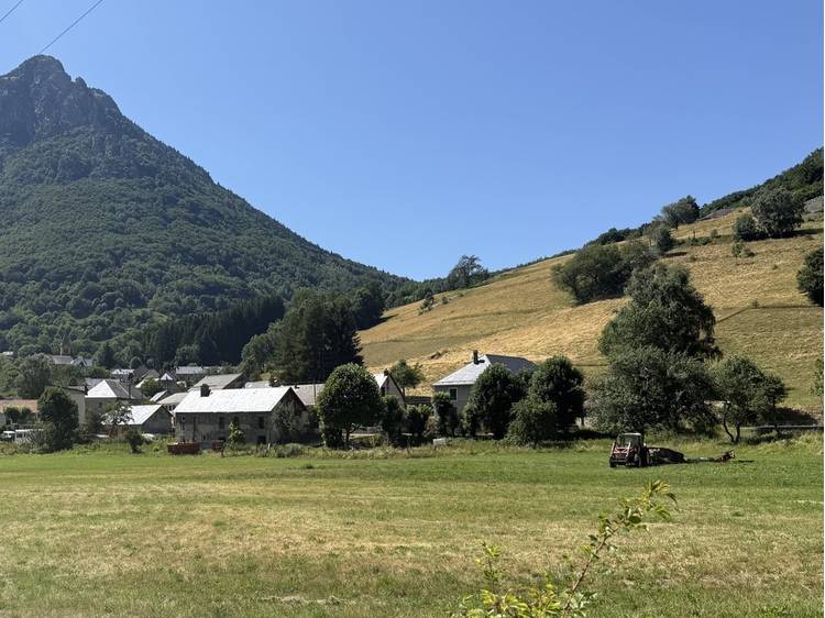
The hamlet of Moulin-Vieux is part of the commune of Lavaldens which holds the record for the valley in number of water points with its 7 wash houses and 35 basins mostly communal. These buildings were built with cast cement during the first quarter of the 20th century.
The washerwomen went to the wash-house to finish the laundry.
Rinsing required a large amount of clear water, available in the wash. They were places of meeting and exchange where women met to joke, laugh away from any male intrusion.
After the summer of 2022, marked by a severe national drought, we become aware of the precariousness of this property.
Go up the Route de l'Eglise D114c, quickly take the Chemin de Blache Rousse for 50m to observe the old flour mill that has not been working since 1957.
Observe the slate roof cover, embellished with 2 jacobin gable rooflights. By focusing our attention on the edge of the roof, we can see a rather rare architectural element in our hamlets, a lambrequin. This ornament is also found on the Jacobines and on three windows of the first floor.
On the side of the terrace, you can examine one of the old stone millstones as decoration. The pool is private.
At the back of the house stands a small building which is mentioned on the land register of 1840, under the name "battoir". This one is also called the small mill.
«The name battoir, already cited around X°s. described the waterwheel that operated the pestles used to soften the hemp canvas leaving the weaver’s home! Practically every miller owned, in addition to his flour mill, his own threshing machine. (cf. "Mémoire d'Obiou" Les Amis du musée Matheysin).
Turn back and return towards the starting point Repère 1.
Next, the first small house on the left, at no. 10 of Chemin de Blache Rousse, has a tilt roof; it is the change in inclination of the roof’s slope that contributes to rejecting water away from the wall and structural timber in order to protect them.
At no. 2 chemin de Blache Rousse, examine the building of the house; this house with slate roofing is adorned with a top wall decorated with a Mediterranean-style Genoese cornice; Moulin-Vieux seems to mark the northern border of this decorative element.
Going down in the hamlet, notice the different Montées de Granges or typical mounts in the farms of the commune.
These ramps allowed access to the outbuildings and the storage of hay. Often under this mountaineer was the "pourci" or hog lodge.
In the Impasse Ser Bérard, stuck to the gable of a house, a pool.
On the right, in the intersection with Impasse de l'Ecole, was the ordinary oven destroyed during the widening of the road.
The old school, completed in 1889, has been closed since the beginning of the 1970s. The children are educated in La Morte, then in La Mure.
Toujours, Route de L'Eglise, on the left a wash-house under shelter – to the right of the barn doors and the traditional barn mounts – Impasse de la Fontaine, private pool.At the foot of the slope on the right, the covered wash house, restored in 1962, marked with the initials HB, its director.
Mark 2
At the intersection, on the left, there are buildings being restored. In 1946, these first buildings were transformed by young teenagers who would create the Children’s Republic of Moulin-Vieux.
(cf "La République d'Enfants de Moulin Vieux" by Serge Chaloin and/or PRTR website).
Ignore the Passage de la Croix and continue straight ahead on the Voie des Carriers: a small neighborhood, where houses line up wisely at the foot of very steep fields, now grazed.
Basin facing no. 17 and its line of tadpole trees.
Marker 3
At the Carriers, a covered wash-house indicates its construction date: 1914.
In the bend, leave the road and go up via the Chauvetat road.
At the level of post Station 3, notice in the plain a large unusual building, planted in the middle of the fields; the "snow chalet" built in 1952 by the residents of the Republic of Children of Moulin-Vieux. «Built by children for children», according to their motto.
At the entrance of the forest, a rocky niche on the left welcomes a statuette of the Virgin.
Go past the rock climbing of Chauvetat.
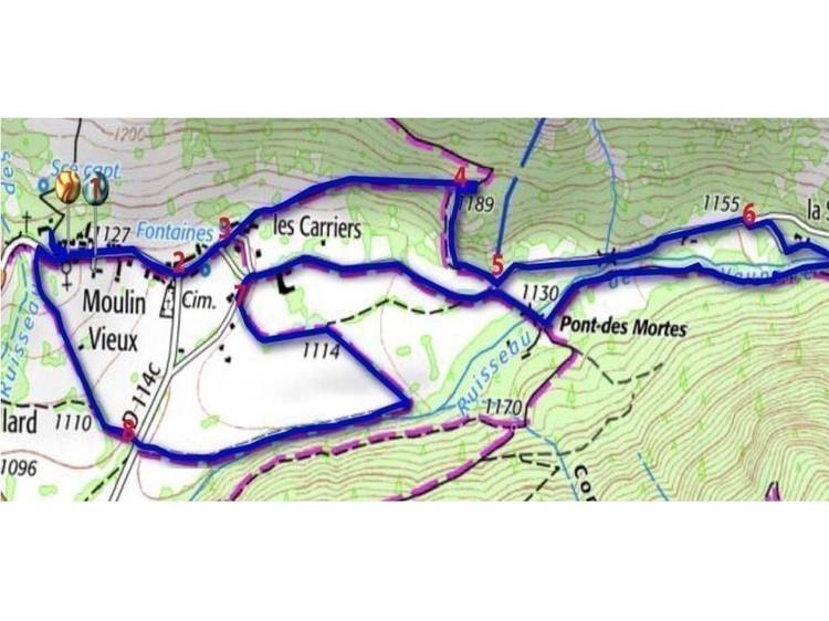
Mark 4
When you reach a flat area at the post "Chauvetat 1190", turn right onto a small road to access the rocky hill and land near the cairn, on top of the Rocher du Goûtaï. This viewpoint was once used by young people who gathered at St Jean to celebrate the "bordalinaïre". The pyre had to launch its flames into the night, higher in the sky than those of neighboring hamlets.
Admire the organization of plots, paths lined with strange silhouettes, stubborn trees.
What is a tadpole tree? A tadpole or trogne tree is a tree regularly pruned for its production of wood or leaves. the recovered branches were put in "bundles" and then stored once dried.This harvest provided additional food for the animals in winter. Goats, in particular, were particularly fond of it. The collected kindling was used to light the stove.
The municipality of Lavaldens holds the record for the number of tadpole trees.
The census carried out in 2019 by "Drac Nature" of La Mure, counted about 10,000.
Admire the panorama on the hamlet of Moulin-Vieux which stretches along the main road, on the glacial plain bordered by the torrent of Vaunoire which takes its source in the massif of Armet on the side of Plancol .
Sweep the dark Peychagny Forest, then the imposing Tabor (2389m) which dominates the Massif du Grand Serre where the altitude domain of Alpe du Grand Serre is located and further to the right, the Col de la Morte which gives access to the resort.
Back on your way to Repère 4.
On the left, follow the sign for Pré Gelas; let yourself slide along the path of the Goutaï draye, which tumbles down very quickly.
(Warning! steep trail requiring good physical condition and proper footwear,
a return by the same route can be considered to find the Repère 5.)
Mark 5
Continue along the path lined with low walls until you reach the Route de la Cascade at the post "Pré Gelas 1130".
Take the road on the left towards the Vallon de Vaunoire.
The torrent of Vaunoire tumbles down from the valley of the Emay overhung by the Taillefer, crossing the lake of the Emay, warming up at the passage of stone slabs and feeding beautiful basins.
Continue on the road and stop at La Loye; this small barn built by the roadside in 1903, summarily converted in 1940, has become a second home for the summer; see its gable with cleavages or jumping sparrows, its brood and its bull’s eye.
Continue for another 250m, until the Mas de la Scie, turn right at junction no. 1899 to see the old sawmill; nearby is the house "Le Solitaire".
Benchmark 6:
Go past the buildings, take the path for 100m. Take a wooden footbridge, turn right. This route takes us downstream of the torrent, on the left bank. Follow the trail in the forest, becoming a path that crosses "Le Pré du Prêtre", near the stream, respecting the meadows.
Go past the "Station 7" stake at the waterfall; turn around and look up to contemplate the Grande Roche or "Orgues du Taillefer".
Move forward to the Pont des Mortes, cross it to reach the Route de la Cascade at point Repère 5 in the direction of the hamlet.
At the junction, leaving the Voie des Carriers and the Passage de la Croix, turn left onto D114c.
Benchmark 7:
"Diverticule champêtre" or future "sentier des poètes":
After 50m on D114c turn left, towards "pré du Villard"; let yourself be guided by the path lined with large stones, to walk along the foot of the forest of Peychagny and alongside the banks of the torrent of Vaunoire.
Arrive at the road D114C and cross it.
Benchmark 8:
Opposite, go up by the Chemin des Jailles.
After a few steps, observe in the slopes the "hutches" resulting from human work. On Sunday, the day of rest, allowed for relaxation in the meadows and fields where the family collected the stones, gathered them to make a large pile, at the edge of the land.
Halfway down the right side of the road, stop at the Sacred Oratory in 2015. He remembers a beautiful story lived in 2007 and told by a resident of the hamlet as a tribute to a couple of pilgrims making their way to Jerusalem, which he unexpectedly hosted for the night. (see story by Hervé Réant here).
At the end of the road on route D114C, turn right to find the church road and its parking lot.
Possible diversions:
From R4, take the opposite path to find R1
From R4 to find R3, then R5, then R6 for a round trip
From R4, find R3, then R7, then R8
From R5, take the R7 road, then the R8.
Track
- Distance:
- 6 km
- Level difference:
- 160 m
- Daily duration:
- 1h 30min
- Level:
- Couples, Children, Walkers/hikers, Level green – easy, Groups, Specially for children, Home school groups, For beginners / novice, Holiday Camps Home
- Type:
- Loop
Rates
Free access.
Opening date
All year round daily.
Subject to favorable weather.
Equipments
- Themed path
- Car park
- Pets welcome